Geospatial Network Uganda

The Future of
Cadastral & Geospatial
Intelligence

An all-in-one professional GIS platform powering cadastral surveys, terrain analysis, property valuation, and real-time collaboration across Uganda — fully aligned with global FFPLA standards.

LIVE PLATFORM — BUILT FOR PROFESSIONALS
Platform Overview

One Platform. Unlimited Capabilities.

GSP.NET unifies the entire geospatial workflow — from raw survey data to professional-grade reports — in a single browser-based application.

50+
Map Layer Types
50+
GIS Tools
8
Export Formats
Real-time
Team Collaboration
Ecosystem Roles

Designed for Every Professional

GSPNET provides role-based access control to ensure the right tools are available to the right professionals.

General User

Mapping features, vector data, public property marketplace, and spatial search capabilities.

Registered Surveyor of Uganda

Quality assurance supervisors managing corroborative surveys, survey quality, and technical dispute resolution.

Valuer

Private vault for comparable sales, automated valuation models, and generation of professional valuation PDF reports.

Land Clerk

Real estate and property management role, focusing on capturing and managing untitled land parcels.

Global Standards

Aligned with FIG FFPLA

Operationalizing the principles of FIG Publication No. 87: Fit-for-Purpose Land Administration across three core pillars.

  • Spatial Framework — Flexible data capture via UAV/GNSS, "Walking the Boundary", & Incremental Upgradability.
  • Legal & Institutional — Continuum of tenure, joint ownership (Gender Equity), and shifting surveyors to RSU QA roles.
  • Social Legitimacy — Dispute resolution via geo-flagging and collaborative logs over rigid court systems.

"Don't start what you cannot sustain"

Our software philosophy follows the Rule of Sustainability. We prioritize configurability and an ecosystem approach, providing critical Services of Engagement and Insight that adapt locally without expensive custom coding.

Strategic Alignment

SaaS Evaluation: FIG FFPLA Standards

Webmap.geospatialnetworkug.xyz fully operationalizes the Spatial, Legal, and Institutional pillars using frontier tech (AI, Cloud, 3D).

Spatial Framework
  • Flexible Data Capture: Hybrid basemaps (Esri, OSM) & digitizing support participatory mapping for rapid scaling.
  • Incremental Upgradability: Edge Functions calibrate 30m Open DEMs with RSU CSV data, enabling the accuracy continuum.
  • 3D Cadastre: Dedicated 3D view for condominium plotting addressing urban vertical tenure security.
Legal & Institutional
  • Continuum of Tenure: Unique IDs for "Untitled Land", providing legal visibility to customary rights.
  • Gender Equity: Joint ownership registration supporting SDG 5 to secure women's land rights.
  • Professional Evolution: RSU supervisors oversee quality logs, shifting roles to "system custodians".
The Multiplier Effect
  • Dispute Resolution: Digital geo-flagging builds social legitimacy through transparent agreement.
  • Environmental Stewardship: Dedicated layers link tenure to climate resilience in protected zones.
  • Automated Valuation (AVM): Real-time valuation based on market pins creates a sustainable business model.
Technical Architecture (FAIR): Scalable infrastructure via PostgreSQL, Supabase, and S3 Buckets ensures Findable, Accessible, Interoperable, and Reusable data. An AI Assistant bridges capacity gaps.
Conclusion: Beyond a mapping tool, it's a comprehensive Spatial Data Infrastructure (SDI) fully aligned with the global roadmap for universal land tenure security by 2030.
Security & Compliance

Uganda Data Protection Act 2019

GSPNET is engineered with Privacy by Design, fully complying with the Personal Data Protection Office (PDPO) mandates.

  • Data Minimization — We collect only the minimum PII necessary for professional land registry work.
  • Strict Access Control — Role-Based Access Control (RBAC) ensures sensitive ownership data is only accessible to authorized actors.
  • Explicit Consent — Robust consent flows before data collection, ensuring accountability, fairness, and lawfulness.

Enterprise Security

Our cloud-native architecture implements advanced technical and organizational measures to safeguard your information against unauthorized access, loss, or destruction.

Core Engine

Interactive WebMap

Powered by OpenLayers with seamless base map switching, real-time feature rendering, and professional cartographic output.

  • Multiple Base Maps — Satellite, Topo, OSM, Terrain & custom tile layers
  • Drawing Tools — Points, lines, polygons with snap-to and measuring
  • Coordinate Search — Jump to UTM, Lat/Lng, or district coordinates
  • Export & Print — High-res map exports with legend & scale bar
Interactive WebMap
Connectivity

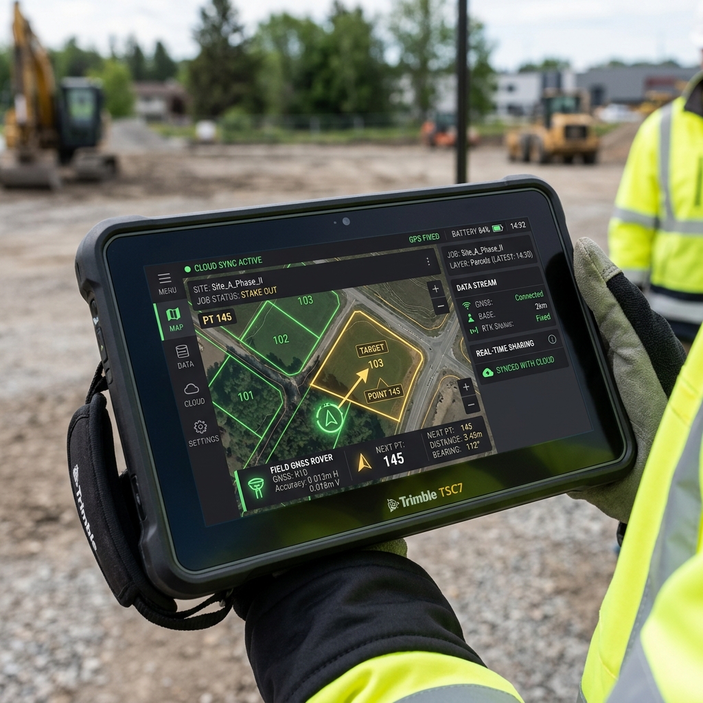
Real-Time Data Sharing

One database. Many clients. Seamlessly connect field equipment to the cloud using WFS and WMS standards.

  • Field Integration — Sync live data directly from GNSS rovers and field controllers to the webmap.
  • Live WFS/WMS — Push and pull geospatial vector and raster layers in real-time across the ecosystem.
  • Cross-Device — Instant access whether you're using laptops in the office, or tablets and phones in the field.
Real-time data sharing on GNSS controller
Terrain Intelligence

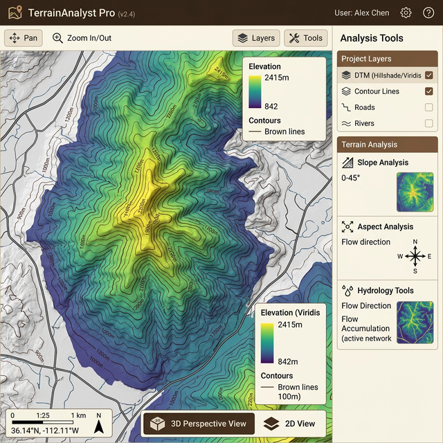
Professional Terrain Analysis

From survey points to production-grade DTMs, contours, 3D visualization, slope maps, and hydrology — all computed in the browser.

  • DTM Generation — IDW/TIN interpolation with QGIS-quality color ramps
  • Contour Lines — Smart-labeled contours with configurable intervals
  • 3D Visualization — Interactive 3D terrain with fly-through navigation
  • Advanced Analysis — Slope, aspect, curvature, hydrology & earthwork volumes
Terrain Analysis
Automated Valuation

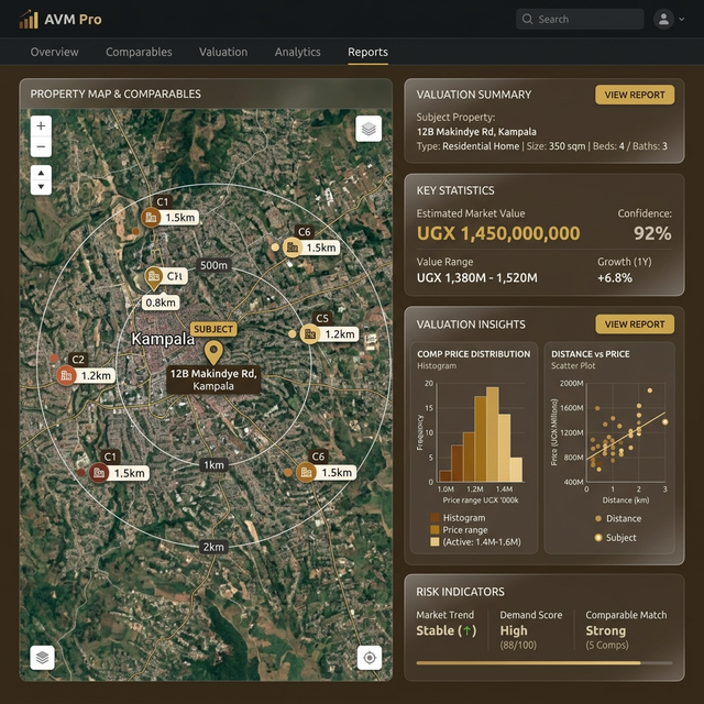
Smart Property Valuation

Comparable-sales based auto-valuation with statistical analysis, confidence scoring, and professional PDF report generation.

  • Auto-Valuation Engine — Land & improvements using comparable sales method
  • Statistical Charts — Price distribution, distance-price correlation analysis
  • Risk Indicators — Confidence scoring, outlier detection, market alerts
  • PDF Reports — Professional valuation reports with comparables detail pages
Property Valuation
Complete Toolkit

Everything You Need, In One Place

Data Import

Import CSV, DWG, DXF, and GeoJSON files. Drag-and-drop with automatic coordinate system detection.

Polygon Creation

Create parcels from survey coordinates with edge function processing, area calculation, and unique ID generation.

Measurement Tools

Distance, area, and bearing measurements with profile cross-sections and earthwork volume calculations.

Symbols Library

240+ professional survey and cartographic symbols organized by category with custom placement.

Quality Flags & Collaborations

Geo-tagged quality control flags with categories, status tracking, and real-time team chat messaging.

Property Marketplace

Mark properties for sale, attach prices, and enable public search. Pricing data seamlessly feeds into valuation models for valuers.

AI Assistant Spotlight

Dedicated 24-hour intelligent chatbot trained on FFPLA standards to assist with workflows and documentation.

SurveySync AutoCAD Plugin

Easens data sharing between AutoCAD and Webmap primary data collection layers, solving data fragmentation.

Technology Stack

Built with Modern Technology

Enterprise-grade architecture leveraging cloud-native services for maximum performance and reliability.

OpenLayers 9
Supabase
PostgreSQL
GeoServer
Cloudflare Workers
Cesium 3D Environments
Chart.js
jsPDF
Delaunator
Edge Functions
Auth & RBAC
Vision & Roadmap

Where We're Headed

Continuously evolving to meet the growing needs of Uganda's geospatial professionals.

Phase 1
Core Platform
Interactive map, coordinate tools, data import and sharing
Phase 2
Terrain & Analysis
DTM generation, contours, 3D viewer, slope/aspect analysis, and hydrology
Phase 3
Valuation Engine
Auto-valuation, comparable analysis, PDF reports & valuation history
Phase 4
AI Assistant
Dedicated 24-hour chatbot integration to support all workflows.
Phase 5
Full AI Automation
Full AI automated tasks running seamlessly across the entire SaaS ecosystem.
Get Started Today

Ready to Transform
Your Geospatial Workflow?

Join the growing community of surveyors, valuers, and land professionals who trust GSP.NET to power their work.

Launch GSP.NET